

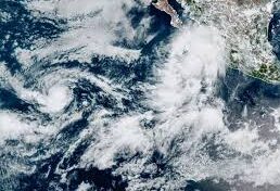
Hurricane Lorena is gaining strength in the Pacific and could slam Mexico’s Baja California peninsula with heavy rain, flash floods, and dangerous mudslides later this week, forecasters warned Wednesday.
The U.S. National Hurricane Center (NHC) in Miami said Lorena has just reached hurricane status with sustained winds of 75 mph. The storm could intensify quickly overnight, but forecasters expect it to start weakening on Thursday and possibly downgrade to a tropical storm by Friday.
As of Wednesday morning, Lorena was spinning south-southwest of Cabo San Lucas. While it only just qualifies as a hurricane, its track has raised concern for communities along Baja California Sur.
Meanwhile, another Pacific storm, Hurricane Kiko, is much stronger but remains far out to sea with no threat to land.
Storm track and warnings
The NHC predicts Lorena will hug the west coast of Baja California today and Thursday before moving closer to shore late Thursday into Friday.
Mexico’s government has issued a tropical storm warning for the stretch of Baja California Sur’s west coast from Santa Fe to Cabo San Lázaro, along with a watch extending north to Punta Abreojos.
What to expect
Forecasters say Baja California Sur and parts of southeast Baja could see 5 to 10 inches of rain, with some spots getting up to 15 inches. That amount of rainfall could trigger life-threatening flash floods and mudslides, especially in mountainous areas.
Hurricane Kiko gaining power
Farther offshore, Hurricane Kiko has already reached Category 2 strength with winds of 105 mph. It’s expected to intensify into a major hurricane later Wednesday, meaning winds could top 111 mph.
The good news: Kiko is not on track to hit land.